Depending on the type of survey undertaken, an ability to understand the specific principles to set-up and help process field data. It could be that different techniques are used on the same site, each providing a layer of data to interpret. Even if you do not intend to become a specialist in this field, understanding the relevant and appropriate techniques will be useful.

PRINCIPLE: To assist in the systematic collection of geophysical data for archaeological imaging or mapping & comprehend basic methodology. – Setting out, collecting and producing the final result
- Novice – Is able to participate in the process of data collection, but would not be able to set up, survey and process data without full supervision.
- Competent – Depending on the Geophysical survey technique used, the individual can assist in all aspects of the process, but may need some supervision.
- Proficient – Can confidently assist in a geophysical survey without prompting for the correct procedures.
Professional tips:
Always locate your survey grid.
Gradiometer survey (also known as magnetometry or magnetic gradient survey) is a passive geophysical method that detects local variation in the strength of the earth’s magnetic field.
Ground Resistance survey, can be thought of as similar to ohmmeters used to test electrical circuits. Archaeological features can be mapped when they are of higher or lower resistivity than their surroundings. A stone foundation might impede the flow of electricity, while the organic deposits within a midden might conduct electricity more easily than surrounding soils Survey usually involves walking with the instrument along closely spaced parallel traverses, taking readings at regular intervals. In most cases, the area to be surveyed is staked into a series of square or rectangular survey “grids”
Resistance tomography survey is a geophysical technique for imaging sub-surface structures from electrical resistivity measurements made at the surface.
Magnetic susceptibility survey; Every kind of material has unique magnetic properties, even those that we do not think of as being “magnetic”. Different materials below the ground can cause local disturbances in the Earth’s magnetic field that are detectable with sensitive magnetometers. The chief limitation of magnetometer survey is that subtle features of interest may be obscured by highly magnetic geologic or modern materials.
Ground penetrating radar survey is a geophysical method that uses radar pulses to image the subsurface. This nondestructive method uses electromagnetic radiation in the microwave band (UHF/VHF frequencies) of the radio spectrum, and detects the reflected signals from subsurface structures. GPR can be used in a variety of media, including rock, loose soil, floors and structures. It can detect objects, changes in material, and voids.
A copy of unprocessed raw data must be retained and archived in order to check results
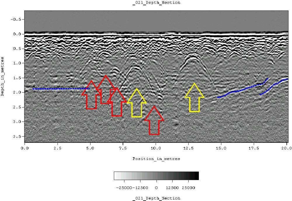
A ground-penetrating radargram collected on a historic cemetery in Alabama, USA. Hyperbolic reflections indicate the presence of reflectors buried beneath the surface, possibly associated with human burials.
Geophysical Survey in Archaeological Field Evaluation 2008, English Heritage (pdf)
2000 Seeing Beneath the Soil: Prospection Methods in Archaeology. Reprint of 1990 edition. B.T. Batsford, London.
Magnetic susceptibility in archaeological prospecting (2013) A. J. Clark