It is good practice on excavations to lay out a grid of 5m squares to facilitate planning. This grid is marked out on-site with grid pegs that form the baselines for tapes and other planning tools to aid the drawing of plans. – In some cases, the contractor may prefer GPS located site plans and sections, but the methods of laying out a site grid, and crucially tying it into a national grid are essential.
Once a site is excavated and plans, sections and finds recorded, they can only be related to each other and the wider picture if you know where they are in Cartesian space.

OVERALL PRINCIPLE: Appreciates concept of site/national grid systems and placement of trenches within this. Can use long-tapes to lay out trenches.
Laying out grids with tapes
PRINCIPLE: Be able to create a grid system and baseline, that can be used for planning or survey – tied into the National Grid.
- Novice – Can assist in the preparation of the grid and understands the concept but needs assistance to complete a grid square.
- Competent – Is able to assist in the creation of a site grid, but all the angles and distances must be checked – understands how to tie into National Grid.
- Proficient – Will be able to lay out a site grid with baseline with no assistance and then relate the grid to a National Grid Coordinate.
Create a trench with right angles
PRINCIPLE: Appreciates concept of site/national grid systems and placement of trenches within this. Can use long-tapes to lay out trenches.
- Novice – understands the concept, but needs more practice in creating the trench outline.
- Competent – Is able to create right angles but may need some supervision to check accuracy.
- Proficient – Will be able to lay out a trench of any size with no assistance .
Professional tips:
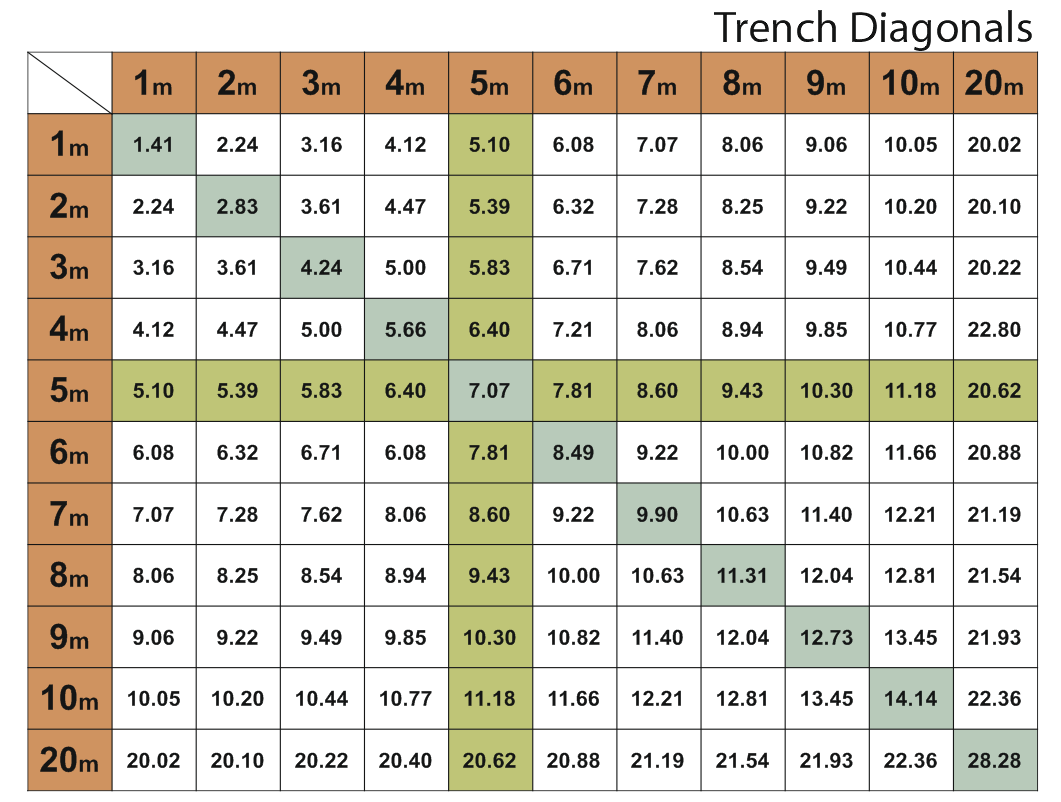
Remember the 3 – 4 – 5 Triangle rule. the diagonal of a 3×4 trench is 5m. Once you have a right angle, you can make a trench of any size. OR use the diagonal calculator below.
Coordinates are always Easting and Northing in the UK and Europe, but can be the other way round in other countries so always put an E and N at the end of a coordinate to save confusion. Remember it by saying “along the hall and up the stairs“
Set out your site grid as close to true North as you can.
Spend time getting the baseline correct.
You can use anything from a Diff GPS to a googlemap to locate yourself. the important point is to locate yourself on the surface of the globe or your project/excavation is “floating” in space.
Find at least two recognisable features that also appear on a map in order to locate your site grid such as a pylon corner, a wall or building, for example.
A very handy too to find the Easting and Northing of Any Point on a map. http://www.gridreferencefinder.com : Just zoom in, change to Aerial View and find a Grid Reference for any point by right-clicking on the Map ! OS coords, and Lat/Long